Monday, June 13, 2011


Monday, May 2, 2011

Sunday, May 1, 2011
RadarScope Weather App
This has to be the best radar app out there. I have been using it for about 8 months now and let me tell you if you want to know the weather this is it. Very easy to use for weather enthusiasts like me I highly recommend this app for your Iphone and Ipad. I currently use this on both and it's simply amazing. This is info from the developers page:
RadarScope is a specialized display utility for weather enthusiasts that allows you to browse NOAA's public NEXRAD Level 3 data feed. It can display the latest base reflectivity, base velocity, storm relative velocity and more data from any NEXRAD radar site in the United States (now including Alaska and Hawaii), Guam, and Puerto Rico.
 It shows your position and will auto locate you in the map.
 The app shows when there is a warning of any type.
RadarScope is a specialized display utility for weather enthusiasts that allows you to browse NOAA's public NEXRAD Level 3 data feed. It can display the latest base reflectivity, base velocity, storm relative velocity and more data from any NEXRAD radar site in the United States (now including Alaska and Hawaii), Guam, and Puerto Rico.
These aren't smoothed PNG or GIF images, this is real Level 3 radar data rendered in its original radial format for a high level of detail.
Whether you are scanning reflectivity for a mesocyclone's tell-tale hook echo, trying to pinpoint the landfall of a hurricane's eye wall, or looking for small features like velocity couplets in the radial velocity product, only RadarScope gives you the power to view radial NEXRAD weather radar on your iPhone or iPod.
Pinch or stretch to zoom in and out. Drag your finger around the map to scroll. Tap the radar sweep button in the toolbar to switch radars. Select one of the more than 140 different radar sites, with the rotating radar beam representing each radar's approximate coverage area. Plot your current position by tapping the location button. Tap the loop button to download and animate over the last six images. Display the names of over 25,000 cities and towns on the map as you zoom and scroll. Tap and hold the color legend to see the data values.
Meanwhile, RadarScope will retrieve and display updated data automatically (approximately every 5 to 10 minutes, depending on the radar scan strategy). NEXRAD radar data are obtained from a public access web site operated by NOAA's National Weather Service.


Sunday, April 24, 2011
Hiking Trip to El Yunque Rain Forest
This is a series of Pics from my last visit to el Yunque National Rain Forest. I took my Maxpedition Falcon II in this trip and let me tell you it is great for long walks. I had a 72oz bladder inside with a 32oz Nalgene bottle in the Maxpedition bottle holder outside and never felt any discomfort.
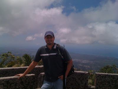
El Yunque as it is commonly known in the Island is the perfect place to spend a day if you love the outdoors.
 One of the many trails.

 Puerto Rico Telephone Company Communication System
 Pico del Este Radar Station
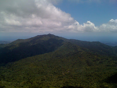
 @the top
 Me and my wife.


El Yunque as it is commonly known in the Island is the perfect place to spend a day if you love the outdoors.


Sunday, April 10, 2011
Tuesday, April 5, 2011
Follow this rules if you want to survive. The Survival Rule of Threes is a convenient way of memorizing the order of importance for each basic survival necessity. In extreme survival situations you cannot survive more than:
- 3 minutes without air
- 3 hours without shelter
- 3 days without water
- 3 weeks without food
Wednesday, March 23, 2011
Tsunami Drill on March 23
Well what can I say the drill as always was not taken seriously by many people. I have been monitoring certain frequencies to get some information on what's happening but nothing. Here in my hometown of Yabucoa we didn't heard not a single siren or warning except the one from the SJ Weather Service. The frequency used by the Emergency Management Office here in Yabucoa is completely silent. The warning was receive by my Yaesu VX-7R and the tsunami drill began. I must say that the state police is participating in the drill and I just heard some type of exercise on their frequency not sure what they were suppose to do.
More info on the Tsunami Drill:
Caribbean tsunami drill planned for March 23 — UNESCO news release:
More info on the Tsunami Drill:
Caribbean tsunami drill planned for March 23 — UNESCO news release:
Full-scale simulated tsunami alert in Caribbean
Paris, 17 March – Following the devastating tsunami that struck Japan, 33 countries* are preparing to participate on 23 March in the first full-scale simulated tsunami alert exercise in the Caribbean. The goal is to test the Tsunami and other Coastal Hazards Warning System for the Caribbean and Adjacent Regions, which was established in 2005 by the countries of the region in collaboration with UNESCO’s Intergovernmental Oceanographic Commission (IOC).
According to the scenario developed by the organizers** of the exercise, countries in the Caribbean will receive an alert on 23 March concerning a fictitious earthquake of 7.6 magnitude off the coast of the American Virgin Islands. Bulletins will be issued by the West Coast/Alaska Tsunami Warning Center (United States) for Puerto Rico and the Virgin Islands, and by the Pacific Tsunami Warning Center (PTWC) in Ewa Beach (Hawaii, US) for the rest of the area.
The exercise, named Caribe Wave 11, does not involve communities. It aims to test the effectiveness of alert, monitoring and warning systems among all the emergency management organizations (national focal points for tsunami alerts, weather forecast offices, national coast guard, etc.) throughout the region. The test is designed to determine whether Caribbean countries are ready to respond in the event of a dangerous tsunami.
Previous experience underlines the crucial importance of rapid transmission of information. It has also shown that national authorities must take risk into account at all levels, including education about hazards in schools, urban planning in coastal zones, modification of building codes and materials, evacuation plans for communities and organization of effective emergency services.
Over the last 500 years, 75 tsunamis have occurred in the Caribbean. This figure represents about 10% of the entire number of oceanic tsunamis in the world during that period. Tsunamis – caused by earthquakes or landslides, or of volcanic origin – have killed more that 3500 people in the region since the mid-19th century (source: National Oceanic and Atmospheric Administration, NOAA). In recent decades, an explosion in population growth and the number of tourists in coastal areas have further increased the region’s vulnerability.
Monday, March 21, 2011
Saturday, March 19, 2011
Earthquake Preparedness
Lately here in Puerto Rico the earth is shaking more than it usually does. Since may 2010 there have been 4 earthquakes of a 5.0 magnitude or more. I have personally felt three of them and let me tell you this is not a common occurrence here in the island. Usually we felt one every two or three years but this series of earthquakes has got me thinking about what to do in case of an emergency. Let me ask you. Are you prepare for a strong earthquake? how about a tsunami? A tsunami wave in Japan destroyed everything six miles inland and I only live about 1.2 miles from the coast. So there is the possibility that my home town can be hit by a tsunami in the future so I decided not to wait and I already started preparing. Here is a list of things I have done already.
1. I have a Bug Out bag ready one for my wife and one for me.
2. I have already developed an scape route with three possible roads.
3. A way to communicate with each other.
4. Where to meet in case of an emergency.
This is a list so far but I will update soon.
1. I have a Bug Out bag ready one for my wife and one for me.
2. I have already developed an scape route with three possible roads.
3. A way to communicate with each other.
4. Where to meet in case of an emergency.
This is a list so far but I will update soon.
Thursday, March 17, 2011
Radiation detected at U.S. Airports
WBBM Newsradio 780 in Chicago is reporting that radiation has been detected at Ohare Airport on passengers arriving from Tokyo. The passengers triggered radiation detectors while being screened by Customs.
The Chicago Aviation Department said they are adding additional screening procedures as a precautionary measures.
Homeland Security would not comment on the situation in Chicago but officials at California’s LAX said that DHS is stepping up screening efforts. Radiation was also detected on passengers arriving at Dallas-Fort Worth. The aircraft’s cabin filtration system also tested positive for radiation.
The Chicago Aviation Department said they are adding additional screening procedures as a precautionary measures.
Homeland Security would not comment on the situation in Chicago but officials at California’s LAX said that DHS is stepping up screening efforts. Radiation was also detected on passengers arriving at Dallas-Fort Worth. The aircraft’s cabin filtration system also tested positive for radiation.
Sunday, March 13, 2011
Friday, March 11, 2011
Friday, March 4, 2011
Want to know what emergencies are happening around the world?
This is the most complete website I have found on the net so far. It's called RSOE EDIS (The National Association of Radio Distress-Signalling). This page is has every bit of information bout every part of the world.

Enjoy!

Subscribe to:
Posts (Atom)